Length of Paved and Unpaved Roads in Kenya – Bitumen and Earth Roads
Length of Paved and Unpaved Roads in Kenya – Bitumen and Earth Roads
Roads are important pieces of infrastructure that link people and communities to economic opportunities. Roads reduce travel costs and travel time, while increasing accessibility and mobility.
In Kenya, counties that had a higher Rural Access Index (RAI) were defined by their populations living within two kilometres of an all-season road. These counties also had higher standards of living than those that did not have significant access to road networks.
This article highlights the length of Kenyan roads by type and classification, and whether they are paved or not.
Quick Facts
- Kenya's total length of roads was 239,123 km in 2025, consisting of 25,412 km of paved roads and 213,711 km of unpaved roads.[1]
- The percentage of Kenyan roads that were paved was 10.6%.
- The share of paved national roads was 35.2%, compared to only 2.9% of county roads.
- As of 2025, Kenya had 365 kilometres of superhighways.
- Murang'a County leads with 70.5% paved rural Class C roads.
The total length of Kenyan roads
As of 30th June 2025, the total length of Kenyan roads was 239,123 kilometres. A majority of these roads were earth/gravel roads, amounting to a total length of 213,711 kilometres.
Roads paved with bitumen, on the other hand, accounted for only 10.6% of the total road network at 25,412 kilometres.

A majority of national roads are paved with bitumen compared to county roads
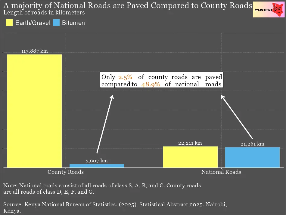
National roads in Kenya totalled 57,071 kilometres. Of these, 20,085 kilometres (35.2%) were paved with bitumen.
On the other hand, county roads totalled 182,052 kilometres. Of these, only 5,327 kilometres (2.9%) were paved with bitumen.

The total length of international trunk roads in Kenya
The total length of class A roads or international trunk roads was 8,590 kilometres in June 2025.
Of these roads, 5,847 kilometres were paved with bitumen, while 2,743 kilometres were made of gravel or earth.

The total length of national trunk roads in Kenya
These are also called class B roads and totalled 15,879 kilometres in 2025. Paved national trunk roads totalled 6,880 kilometres, while unpaved ones were 9,099 kilometres.

The total length of primary class C roads
The total length of class C primary roads in Kenya was 18,568 kilometres. Paved primary roads were 8,747 kilometres, while gravel or earth class C roads were 9,821 kilometres.

Total length of other roads in 2024
A majority of Kenyan roads are county roads, classified as class D, E, F, and G. Only a few of these roads are paved, with a large majority being earth and gravel roads.
|
Road Class (2025) |
Earth/ Gravel (km) |
Bitumen (km) |
|
Secondary Roads Class D |
16,044 |
751 |
|
Minor Roads Class E |
18,491 |
933 |
|
Special Purpose Roads Class F |
28,216 |
778 |
|
Unclassified Roads Class G |
113,974 |
2,965 |
Percentage of paved Class C rural roads
The total length of Class C rural roads in 2025 was 28,19.9 kilometers. Of these roads, 5,163.3 kilometers were paved while 22,986.6 remained unpaved. Overall, only 18.3% of rural class C roads were paved.
Murang'a County leads with the largest percentage of paved Class C rural roads at 70.6%, followed by Kiambu at 54.7%, and Nyeri at 52.5%.
Counties with the smallest percentage of paved Class C rural roads include Mandera at 0%, Turkana at 0.1%, and Kajiado 0.3%.

Download the dataset: Share of Paved Rural Roads in Kenya by County
How are Kenyan roads classified?
Kenyan roads are classified by class, with national roads consisting of roads of class S, A, B, and C. On the other hand, county roads consist of those of classes D, E, F, and G.
Class S roads are superhighways, such as Thika Road.
Class A roads are also called International Trunk Roads. These roads connect important corridors and routes, linking international boundaries and various points of entry into the country, including airports and seaports. An example of a class A road is the A104, starting in Mombasa and concluding in Malaba.[2]
Class B roads are also called the National Trunk Roads. These roads link the county headquarters and other major economic and trading centres to the capital. National Trunk Roads also direct their traffic into class A roads. A good example is the B7 road, which starts in Mai Mahiu through Narok, Bomet, and Kaplong.
Class C roads are also called primary roads and link county headquarters to each other. Additionally, these roads direct their traffic to class A and B roads. An example of a class C road is the Naivasha Moi South Lake Road.
Class D roads are also called secondary roads and link constituency headquarters to each other and to other municipal and town councils. An example is the D 2038 in Nairobi, also called the United Nations Avenue.
Class E roads are also called minor roads, and direct local traffic to class D roads while also linking important centres within a constituency.
Class F roads are special-purpose roads and link residential, industrial, and commercial areas and properties. They also provide access in various government institutions such as National Parks, hospitals, schools, and prisons.
See Also
- Rural Access Index in Kenya by County
- Best Counties in Kenya to Live in – Basic Access Index
- Human Development Index by County
- Dataset: Share of paved rural roads in Kenya by county
References
[1] Kenya National Bureau of Statistics. (2026). Economic Survey 2026. Nairobi, Kenya.
[2] Kenya Roads Board (n.d.). Rural Access Index (RAI). Accessed from https://maps.krb.go.ke/kenya-roads-board12769/maps/119381/7-rural-access-index#